Scientific Overview and Forecast Diagnostics
Jim Steenburgh
NOAA Cooperative Institute for Regional Prediction
Department of Meteorology
University of Utah
|
Lake Effect of the Great Salt Lake: Scientific Overview and Forecast Diagnostics Jim Steenburgh NOAA Cooperative Institute for Regional Prediction Department of Meteorology University of Utah |
1. Overview of Event Characteristics
2. Forecasting Methodology
3. Predictability Limitations
4. Potential Forecast Diagnostics
5. Observations of lake-effect events
6. References
7. Acknowledgements
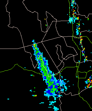
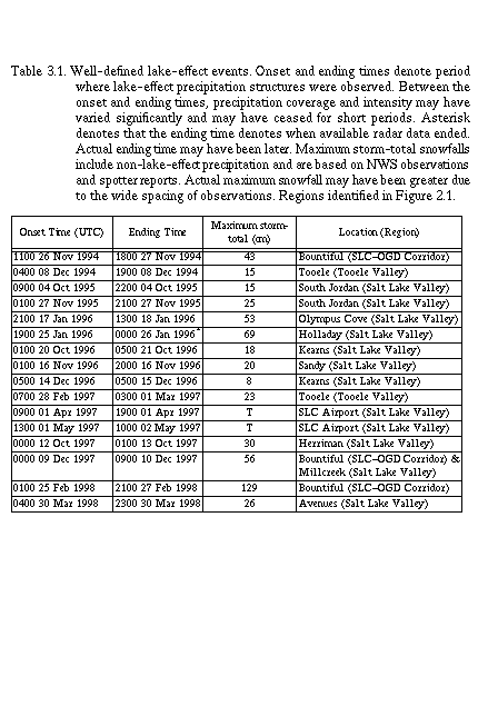
Lake-effect snowstorms produced by the Great Salt Lake represent a major winter-season forecast challenge for meteorologists in northern Utah. Such storms are notoriously difficult to predict and have major socio-economic impacts. Lowland snowfall of 10-30 cm is common, and in extreme events, lake-effect precipitation has contributed to storm total accumulations of as much as 130 cm.
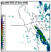
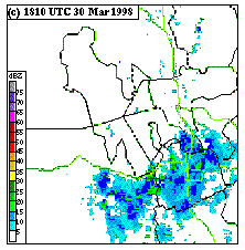
Progress in the understanding and prediction of these events has been hampered by several factors, including a lack of radar and surface observations over and around the Great Salt Lake. Installation of a new Doppler radar by the National Weather Service on Promontory Point in 1994, and subsequent expansion of the Mesowest Cooperative Networks of the Western United States in the late 1990s, has greatly improved our ability to monitor lake-effect precipitation events.
Several studies have examined lake-effect snowstorms produced by the
Great Salt Lake (e.g., Carpenter 1993; Halvorson 1998; Slemmer 1998;
Onton 2000; Steenburgh et al. 2000; Steenburgh and Onton 2001; Onton and
Steenburgh 2001).
Building on previous investigations of similar
events over the Great Lakes, these studies have identified several
characteristics of the Great Salt Lake and the lake-effect snowstorms
that it produces:
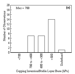
The characteristics described above suggest that an ingredients based approach (e.g., Doswell et al. 1996) for predicting lake-effect events may be justified. We believe that lake-effect precipitation is produced by moist convection, and therefore all the following ingredients are required for an event to occur:
It is unclear how rapidly predictability decreases for lake-effect events as lead-time increases. While some have hypothesized that fixed surface forcing in regions of complex orography may extend predictability, it is also possible that such forcing will merely accenuate model errors and biases, resulting in more false alarms and decreased skill.
Considering the errors found in present day modeling systems, it is not surprising that lake-effect precipitation associated with the Great Salt Lake is difficult to predict. At just 12 h, the average Eta-model winter-season root-mean-squared errors over SLC are 1.6 C, 15 m, 18%, and 5.5 m/s for 700-mb temperature, height, relative humidity, and wind speed, respectively (White et al. 1999). These errors are very significant given the sensitivity of moist convection to small changes in the large-scale environment.
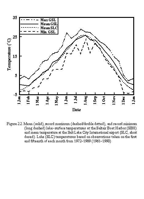
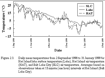
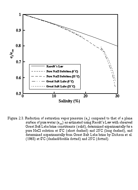
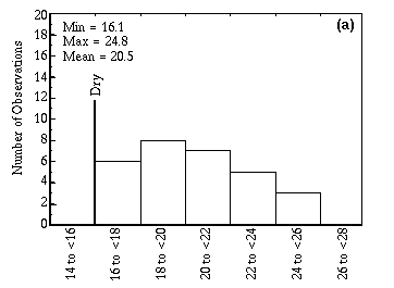
In addition, lake-surface temperature, and its impact on boundary-layer modification, are also not well known. Observations are taken at only two points (HAT and GNI), and most meteorologists simply use the latest reports from these points as an estimate of lake-surface temperature. In a typical day, however, the lake-surface temperature fluctuates approximately 2C, and when cold air moves over northern Utah, the lake-surface temperature can fall several degrees. Therefore, an additional source of uncertainty is the estimate of lake-surface temperature during the forecast period.
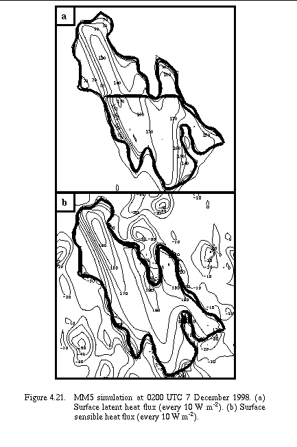
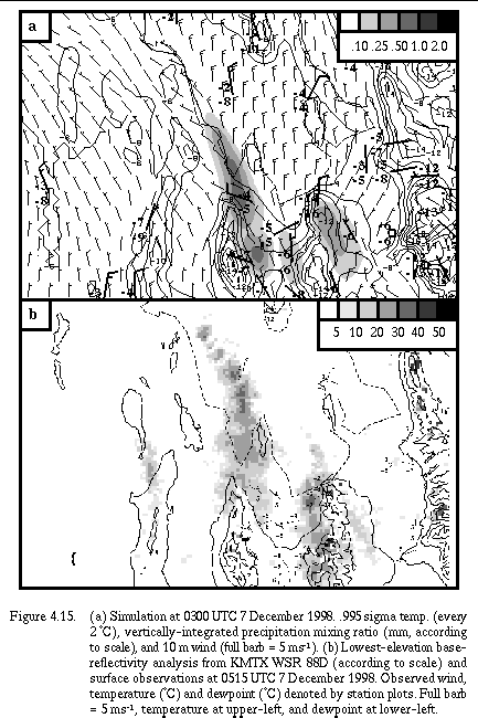
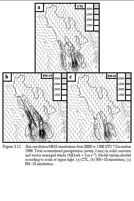
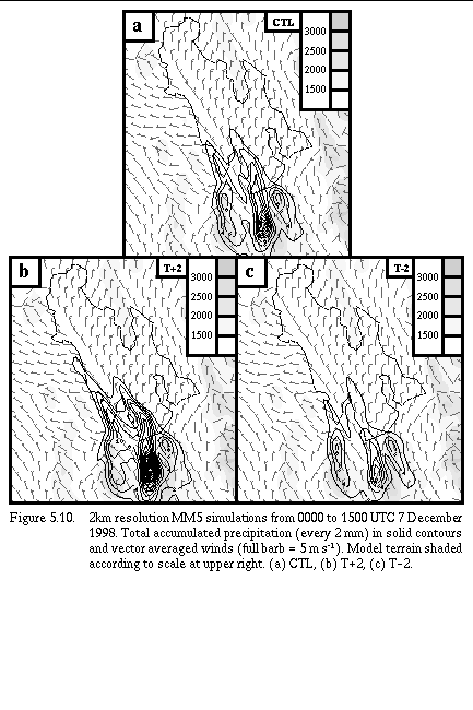
To illustrate the sensitivity of lake-effect precipitation to some of the uncertainties described above, we ran simulations of the 6-7 December 1998 lake-effect event that incorporated changes in the relative humidity and lake-surface temperature. Significant differences in the QPF were found for minor changes in the ambient relative humidity (+/- 10%) and lake temperature (+/- 2 C). These results illustrate that uncertainties in model forecasts and the observation of lake temperature should be considered by forecasters, particularly when applying parcel methods to model soundings.
The recently developed real-time MM5 at the University of Utah is the only modeling system available to SLC forecasters that resolves, to some degree, the Great Salt Lake. Run with an inner grid resolution of 12-km, twenty-nine grid points are treated as water, with the lake temperature for the entire simulation set to the most recent observation at HAT. The model lake will have an impact on wind, temperature, and precipitation forecasts, although the skill of such forecasts has yet to be determined. Subjective experience from last year suggests that the 12-km MM5 may overpredict the number of heavy precipitation events, although it did provide accurate guidance for the two potential lake-effect events that were observed in October 1999. Forecasters should note that errors in the large-scale forecast significantly degrade the utility of high resolution models. If the large-scale is not forecast well, then the mesoscale forecast will likely have problems. Careful evaluation of the MM5 is needed this winter to determine its operational utility.
A variety of diagnostics are currently being tested to determine their utility for nowcasting applications. A long laundry list of potential products is provided below. These products utilize experimental products like the Utah ADAS and diagnostics derived from the Utah Mesonet. Eventually, we hope to reduce the product list and also extend our efforts to longer-range prediction using NWP guidance such as the University of Utah real-time MM5. We encourage you to evaluate the utility of the products below for nowcasting and diagnosis of lake-effect events. Please note that these products are usually current, but may at times be old depending on product availability at the University of Utah.
| Objective | Product(s) | Comments/Caveat | ||||||
| Regional-scale overview | Obtained from NCEP. Usual caveats about regional data assimilation system analyses apply. Link included here simply for student use at University of Utah. | |||||||
| Mesoscale precipitation structure |
| Available only to University of Utah. Link included here for student use at the University of Utah. | ||||||
| Mesoscale wind/temperature structure | | Wasatch Front mesonet observations. Locamotive Springs not on
plot yet.
| | ||||||
| Thermodynamic structure, instability, and boundary-layer modification by the GSL | | For assessing convective environment. Forecasters should first
use observed SLC sounding to assess convective conditions.
| | ||||||
| Low-level moisture distribution and boundary-layer modification by the GSL | | Can also be used for interactive sounding analysis.
| Lift/land-breeze convergence |
Calculated using mesonet observations over and surrounding the
Great Salt Lake; Developed by Mike Splitt and Bryan White |
Steering-layer flow
| PRP is probably the best observation above lake-level for
approximating steering-layer flow
| |