 |
Wind Systems of the Mountain West:
Project Overview
Jebb Q. Stewart
Undergraduate Research Assistant
NOAA Cooperative Institute for Regional Prediction and
Department of Meteorology
University of Utah
Faculty Advisors:
Jim Steenburgh, University of Utah
C. David Whiteman, Pacific Northwest National Laboratory
|

Introduction
The complex topography of the western United States produces a
wide variety of thermally- and dynamically-driven mesoscale wind
systems. Historically, knowledge and understanding of such systems has been
limited by a variety of factors, including limited observational
data.
Over the past few years, data from a variety of meteorological observing
networks has been collected as part of the Utah Mesonet,
a collaborative project between the University of Utah/NOAA
Cooperative Institute for Regional Prediction and National Weather
Service Salt Lake City Forecast Office. Presently, data is collected
from over 25 observing networks and 1300 surface stations over the
Mountain West.
The primary objective of this project is to produce a climatology of
Mountain West wind systems using observations collected by the Utah Mesonet.
Wind roses, vector winds, and hodographs are presently available for several
regions and seasons. Additional high resolution analyses for areas
such as the Tooele Valley, Salt Lake Valley, Truckee Basin, and Las
Vegas basin will be added in the near future.
Data and Methods
Using computer modem dialout and anonymous ftp, the Utah Mesonet collects data from
meteorological networks maintained by a variety of
government agencies and commercial firms, with data stored at the University
of Utah in GEneral Meteorology PAcKage (GEMPAK) format. Because
each network is designed to meet the needs of the operating agency or firm, there is
considerable variance in the reporting intervals, station density, and meteorological
equipment in each network. Since real-time quality control algorithms for wind
observations are presently under development, a relatively simple scheme was
implemented for this project to eliminate grossly erroneous data. This involved
removing missing data reports, observations of calm conditions or the same wind speed
and direction for more than three successive observations times, and the removal of
reports with high unlikely wind speeds (i.e., 75 m/s). At a given location vector-averaged
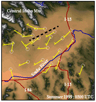
winds, wind roses, and hodographs were generated for each season at hourly intervals
using all reports within 15 minutes of the top of the hour, provided a minimum of 60
observations were available. Cumulative and individual winter (DJF) and summer (JJA) season
statistics were generated using data from Dec 1997 through Aug 1999.
Wind roses were generated by segregating wind direction observations at 22.5
degree intervals (for the 16 compass points) and wind speed observations at
2.5 m/s intervals. Vector-averaged winds were calculated by breaking down the
wind into U and V components and determining the mean for each component. Thus, the
vector-averaged wind magnitude is typically lower than the mean wind speed due
to vector cancellation (e.g., a north and south wind of the same magnitude average
to calm conditions). Hodographs were created using the vector-averaged wind at
3-h intervals, with the hodograph vector pointing from the tip of the wind vector
at time t to the tip of the wind vector at time t+3.
 Back
Back