Menu:
Research
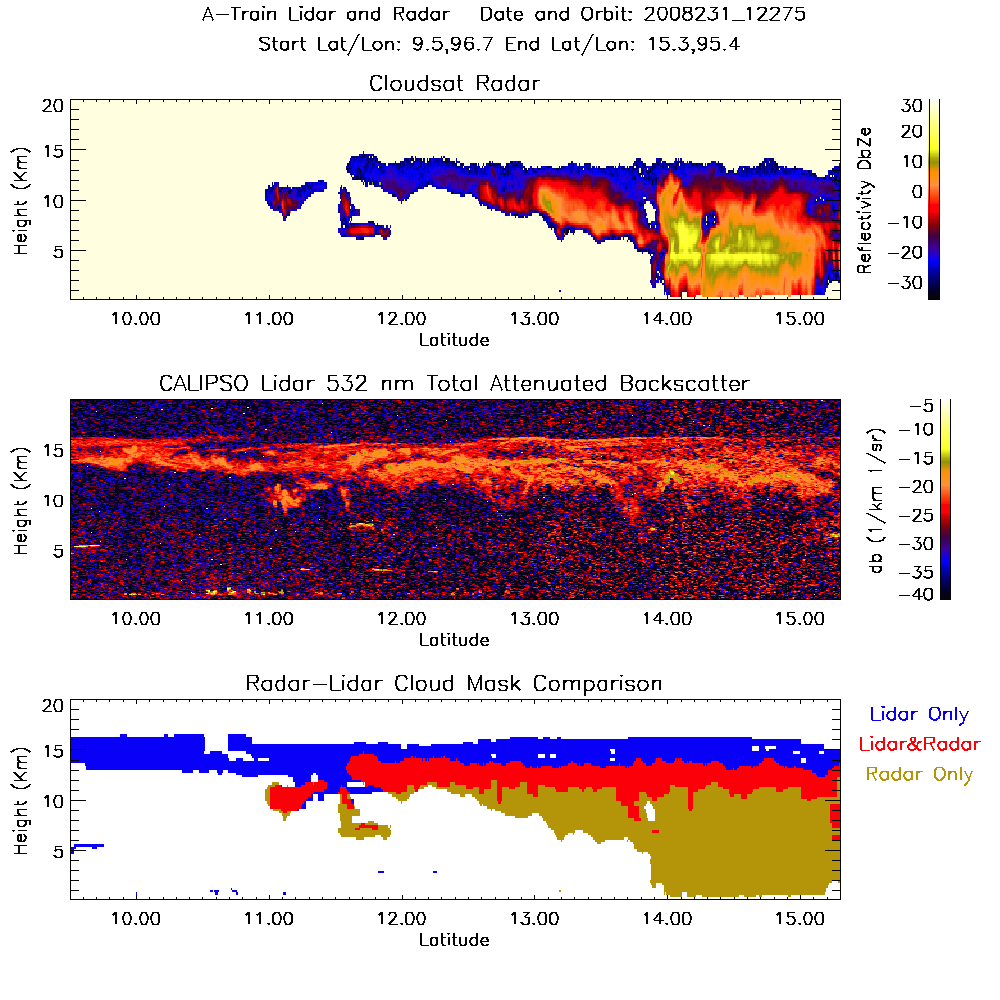
My research is focused on using space-based remote sensing to study clouds and their impact on the climate. I primarily use data collected by satellites in NASA's A-Train constellation, including the cloud radar on CloudSat and the lidar on CALIPSO. Shown below is an example of a deep convective cloud and cirrus anvil that was observed by the A-Train in the Tropics.
Some of my research interests include:
Remote Sensing of Cloud Ice
While global mean liquid water path shows good agreement among different climate models, there are large intermodel differences in global mean ice water path. Ice water path is not as well constrained as liquid water path. This is due to a number of reasons, including the historical difficulty in observing clouds in the upper atmosphere, and the complexity of ice crystal shapes compared to spherical liquid drops. A new data product called 2C-ICE uses the vertically-resolved information from CloudSat and CALIPSO to retrieve ice cloud properties and is helping to improve our understanding of ice-phase clouds. We've used this dataset to examine what portion of the total ice water path distribution is observed by the radar versus lidar. Knowing this is useful for understanding biases in other climatologies and also for planning future satellite missions.
Cloud Radiative Effects
Different cloud types will warm or cool the planet compared to clear-sky conditions. We use the A-Train data to investigate these cloud radiative effects during the monsoon season in Southeast Asia, one of the cloudiest places on Earth. Once we derive the cloud microphysical properties we use those quantities to calculate the cloud radiative properties, which are used as inputs into a radiative transfer model. While prevalent cirrus clouds have a moderate warming influence, less frequent deep convection has a strong cooling effect. We find that the net effect of clouds on this region is largely a balance between these two cloud types, producing a near zero net cloud radiative effect at the top of the atmosphere.
Aerosol-Cloud Interactions
Many studies that examine aerosol-cloud interactions are based on modeling experiments, since it is inherently difficult to observe both cloud and aerosol with remote sensing methods. One outstanding question is whether aerosols act to invigorate convection, as there is a theory for why this should be, but researchers have found mixed results depending on their modeling scheme. I have attempted to use remote sensing observations to investigate this question by looking at the aerosol optical thickness from the MODIS instrument in clear pixels surrounding cirrus anvils that were observed by CloudSat. Then while controlling for differences in the large-scale environment, I compare the effective radius for ice crystals in clean and polluted cirrus anvils. Based on the theory of convective invigoration, one would expect to find smaller sized ice crystals in environments with more aerosol.
Relationship between Clouds and Large-Scale Dynamics
On a global scale, the large-scale dynamics largely determine where certain clouds will form. One can see this on any given day by looking at a satellite image. In addition, clouds themselves feedback on the large-scale dynamics through processes like radiative heating and evaporation. But to what extent does the large-scale meteorology predetermine the cloud properties? To address this question, I used a k-means cluster analysis to objectively defined cloud types based on their vertical structure, and then I used reanalysis data to create composites of the large-scale meteorology for each cloud type. Next I did just the opposite. I used the cluster analysis to define large-scale dynamic regimes and then created composites of the cloud characteristics that are found in those dynamic regimes. If the cloud properties were solely determined by the large-scale dynamics, one would find that the same cloud types would emerge from both sorting methods.
Cirrus Evolution
One disadvantage of the A-Train satellites is that they only provide a snapshot of the atmosphere. So the A-Train will observe a cloud at one point in time, but it does not tell us anything about the lifecycle of that particular cloud. However, we can augment the instantaneous view of the A-Train with geostationary satellites, which take a scan of the same area approximately every 15min. Then with a Lagrangian tracking algorithm, we can follow the cloud in time (see example below). This allows us to determine whether the cloud can be traced back to a convective origin, if it growing or dissipating, and it's overall lifetime.